Friday 31 January 2014

more scary weather stuff

North Atlantic Ramping up to ‘Storms of My Grandchildren’ to set off Major Flood Event for Tempest-Tossed England and Cornwall?

Storms Reshape England's Coastline
(Storms Reshape Cornwall’s Coastline during Winter of 2013-2014. Image source: AGU)

Under the ongoing insults of human-caused climate change, the North Atlantic is ground zero for the potential development of the worst storms humankind has ever experienced. And indications are that the ramping up to this dangerous time may well be starting now.

The temperature related weather instabilities between the warming North Atlantic, the melting but still frigid ice packs of Greenland, the retreating polar sea ice, a continental North America enduring a series of polar vortex collapse events flushing cold air south as the Arctic experiences its warmest readings in an age, and an interior Europe and Asia that are also experiencing mass migrations of cold air fleeing the ever-warmer Arctic are just screaming.

A bite of warm air and related warm ocean water has flooded a large region between Scandinavia, Svalbard and Novaya Zemlya, making its home where winter sea ice once resided. The waters near Greenland are now melt-cooled by the 500 gigatons of average annual glacial outflow occurring there. And the never-ending influx and concentration of heat in the Arctic has set the Jet Stream into a fit of wild loops and whirls.
All these changes result in a high degree of weather instability, in a setting off of extreme weather events, of great switches from cool, to extreme hot, from record drought to record deluge. In the past few years we’ve seen these kinds of extreme weather events occur with increasing frequency. But now, a new kind of extreme event is beginning to emerge, a kind of event that may well be prelude to ‘The Storms of My Grandchildren’ Dr James Hansen alluded to in his prescient book examining the ultimate consequences of an ongoing and devastating human greenhouse gas emission.

The Breeder of Storms: Our Warming-Ravaged North Atlantic

Ever since winter began to settle in, and the extreme effects of Northern Hemisphere temperature imbalance and Jet Stream changes began to take hold, the North Atlantic has become a breeder of extraordinarily powerful storms. According to reports from NOAA’s Ocean Prediction Center, the month of December alone featured 14 instances of hurricane wind events, 10 storms that experienced rapid intensification, and 5 storms that featured pressures of 950 mb or lower.

For comparison, a tropical storm that hits 950 mb is usually a category 5 hurricane. And for any ocean basin to show 14 instances of hurricane force winds let alone 5 950 mb and below storms over a one month period is extraordinary indeed. Imagine if the south Atlantic generated 10 hurricanes 5 of which were cat 5 in just one month and then you get a general comparison.

Two of these storms were particularly intense with one reaching 940 mb and another deepening to an exceptionally low 929 mb (the lowest reading ever recorded for the North Atlantic was 916 mb). By comparison, the freakish monster that was Hurricane Sandy bottomed out at 940 mb.

It is worth noting that the storms of the North Atlantic typically spread their energy out over larger areas than a tropical system. So though pressures are low enough to be comparible with the most intense tropical storms, the winds generated typically ranged from 75 to 100 mph while extending outward over hundreds of miles. By comparison, a typical tropical cyclone would have a very intense wind field within 20 to 100 miles of its center with intensity rapidly falling off beyond this zone.

Overall, the North Atlantic sees very few storms of 940 mb or lower, usually at the average rate of less than one every year. So for two to occur in the same month is exceptional indeed.

929 mb low raking the coast of England on Christmas Eve
(929 mb low rakes England with hurricane force winds on Christmas Eve, 2013. Image source: Lance-Modis.)

January also featured an almost endless cavalcade of intense storms rushing across the North Atlantic with numerous lows bottoming out below 950 mb (NOAA will issue a final tally sometime in February).

Meanwhile, powerful storms developing in the North Atlantic continually pummeled Europe throughout most of the winter of 2012-2013 resulting in some of the worst rain and snowfall events ever recorded.
This recent climate-change driven shift of the North Atlantic into an increasingly stormy weather pattern may well be a prelude to even more extreme changes to come. Weather models produced by GISS and examined by premier climate scientist James Hansen indicate that very powerful storms arise in conjunction with increasing Greenland melt. Large pulses of fresh, cold water entering the North Atlantic were observed to create climate instabilities that resulted in very powerful storms with frontal systems the size of continents that packed the punch of hurricanes in the physical model runs. It was the likelihood that such storms could emerge by or before mid-century that, in part, spurred Dr. Hansen to write his prescient book — The Storms of My Grandchildren.

As noted above, the current Greenland melt outflow averages about 500 gigatons each year. This outflow is already large enough to weaken the Gulf Stream and set off severe weather instabilities. But with Arctic warming continuing to amplify and Jet Stream patterns bringing more and more warm air over Greenland, melt rates may triple or more over the coming decades, resulting in even more severe weather consequences. So the extreme storm patterns we see emerging in the North Atlantic now are likely just a minor prelude when compared to what we will witness as the years and decades progress.

England in the Firing Line: Windiest December Precedes Wettest January

Currently in the direct firing line of these powerful storms are the main islands of the United Kingdom. Throughout December, England suffered an almost constant assault of storms. In total, five storms, or more than one storm per week brought excessive rains and wind gusts in excess of hurricane force to the British Isles. The results were tens of thousands of power outages, major waves and storm surge events along the coastline resulting in damage to coastal structures and persons being swept out to sea, and increasing instances of flooding over saturated ground.

On record, December 2014 was one of the stormiest ever seen for the British Isles. According to weather data, the month was the windiest since record keeping began in 1969:

Wind Gust Measure Met
(Image source: UK Met Office)

In addition, December also ranked one of the rainiest with many locations seeing 3 times the normal level of rainfall for the month.

As the new year began, the series of severe storms impacting the UK continued unabated through late January. And as of the 28th, South England had experienced its wettest month since record keeping began in 1910. With a month and a half still remaining Southeast England had already experienced its 6th wettest winter season on record.

UK Rainfall
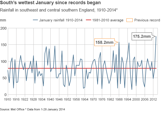
(Southeast UK Rainfall from 1910 to present with 2010 easily setting a new record. Image source: Met Office)

Dr Richard Dixon, director of FES Scotland when commenting in a Guardian interview about the most recent spate of anomalous UK weather noted:
“November and December were record breakers in Scotland, with storm after storm hitting around Christmas. Climate change is bringing chaos to our weather, not just increasing global temperatures but affecting ocean currents and global air currents. Scotland is caught between the changing influences of disappearing Arctic ice, the shifting jet stream and a weakening Gulf Stream. It is no wonder our weather is becoming less and less predictable. The consequences for us are more extreme weather, including more flooding.”
Very Dangerous Flood Situation for Southeast England: Powerful Storm on the Way

The extreme rainfall, as of today, had resulted in a major flood event for Southeast England focusing on the Midlands and Somerset. The event inundated croplands, homes and farms throughout the rural region and spurred England to put its military on standby as forecasts show more rain and high winds are on the way. The anomalous event also spurred the 15th meeting of COBRA, the UK’s emergency response committee which has, increasingly, been called due to a continuous barrage of weather emergencies.

Somerset Floods

(Aerial photo showing homes, businesses and a vast area of land flooded in Somerset, England. Image Source: David Hedges)

In addition to the clearly visible inundation, numerous villages in the region have been cut off due to flooded roads for more than a week (with some areas being cut off for a month). The constant barrage of storms has resulted in both persistently high tides and almost continuous rainfall. The rainfall, trapped by high sea water, has nowhere to escape and simply pools, continuing to build up in the low-lying lands.

The UK’s conservative government’s response to the situation, thus far, has been anemic, waiting until today to declare the region a disaster area.

Unfortunately, another powerful storm is predicted to arrive by Saturday bringing with it yet one more spate of strong winds, heavy surf and driving rainfall to the already soaked region.

Saturday Forecast Map NOAA
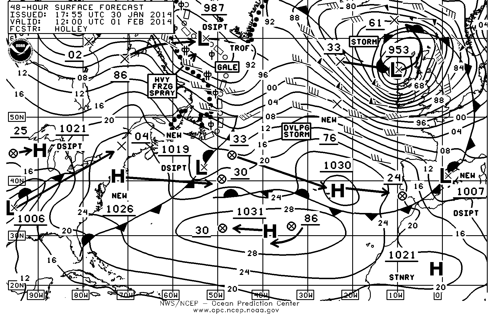
(NOAA forecast map for Saturday. Note a powerful 953 mb storm forecast to impact the UK with 70+ mph winds and heavy rainfall. Image source: NOAA’s Ocean Prediction Center)

So if you’re living in Southeast England please do your best to remain safe, to heed government warnings, and to urge your government officials to provide you with the level of response you deserve during this dangerous time (including policy changes to reduce the rapidly increasing degree of harm coming from human caused climate change).

Early Storms Minor by Comparison

It is worth noting that, though more intense than we’re used to, these storms are the early, weaker outliers of a very dangerous period that is to follow. Our best models and our best climate scientists report the likelihood of far more dangerous storms emerging from this region and from the set of conditions that includes a weakening Gulf Stream, a melting Greenland, an amped up hydrological cycle and rapidly warming zones first at the northern polar region and then in the tropics. The eventual size of these storms could expand to cover continents and involve multiple linked and powerful storm centers. As noted above, Hansen warned of frontal storms large enough to blanket continents and with areas of hurricane strength winds stretching thousands of miles. We haven’t seen anything like that yet. And so the freakish and extraordinary weather we’ve witnessed this winter, and in recent years, is merely prologue for worse events to follow.

Links:

AGU
NASA: Lance-Modis
NOAA’s Ocean Prediction Center
UK Met Office: Winter Storms December 2013 to January 2014
Parts of England See Wettest January Since Records Began
UK Floods: January Rain Breaks Records in Parts of England
Colorado Bob’s Climate Feed
The Storms of My Grandchildren

Wednesday 29 January 2014

alaskan heatwave - in january!!

Arctic Heat Wave Sets off Hottest Ever Winter-Time Temperatures, Major Melt, Disasters for Coastal and Interior Alaska

Major melt in the midst of winter. Doesn’t sound quite right, does it? We tend to think of winter as the time of freezing, as the time of ice accumulation. Not the time of melt and thaw.

Now try this — major melt in Alaska in the midst of winter. Average temperatures 40 degrees hotter than normal in the midst of winter. Rainfall over snow and ice causing avalanches, major road blockages and ice dams to rivers in the midst of winter.

In this instance we have been transported from the somewhat odd into a reality that is completely outside of our previously ‘normal’ context. In this instance we are transported to a time that may well seem like the beginning of the end of the age of ice on planet Earth.

And yet this is exactly what is happening: one of the coldest regions on the planet is experiencing melt and related record heat in January.

For the state of Alaska, the consequences are a strange and freakish winter heat wave, one that features the extreme temperatures mentioned above. For the city of Valdez, as we shall see below, the situation is far more stark.

valdez-avalanche
(Massive Avalanche set off by rainfall, winter warmth, cutting off Richardson Highway to Valdez Alaska and forming a dangerous ice dam of the ironically named Keystone Canyon’s Lowe River. Image source: Alaska Department of Transportation and Public Facilities.)

Hottest ever Winter-time Temperatures for Alaska

On Sunday, a collapse event that flooded the Arctic with heat and ripped the polar vortex in half began. A freakish high amplitude ridge in the Jet Stream that had been pumping warmth over Alaska and into the Arctic for ten months running strengthened. The result was that many regions throughout the state experienced their hottest temperatures ever recorded for that day, month, or season.

According to reports from Weather Underground, Homer Alaska, for example, experienced an all time record high for the day of 55 degrees Fahrenheit, 4 degrees hotter than the previous all-time high set just a few years earlier. And Homer was just one of the many cities sitting in a broad region of extraordinary, 40 degree hotter than normal temperatures. A region extending from the interior to the southern and western coasts. Bolio Lake Range, about 100 miles south of Fairbanks in central Alaska, saw temperatures rocket to 60 degrees, just 2 degrees short of the all-time record high for any part of the state during January (the previous record high of 62 was set in Petersburg, nearly 700 miles to the south and east).

Typically colder high mountain regions also experienced record warmth for the day. A zone 10,600 feet above Fairbanks hit 32 degrees Fahrenheit on Sunday, the highest temperature ever measured for this region during any winter-time period from November through February.

Even before the most recent extreme Arctic temperature spike, January saw numerous powerful heat influxes for Alaska with Nome, Denali Park, Palmer, Homer, Alyseka, Seward, and Talkeetna each setting all-time record high temperatures during the month.

These records come on the back of a long period of rapidly increasing Alaskan heat stretching all the way back to the 1970s. In many cases, we are seeing all-time record highs broken with 5-10 year frequency. In the most extreme cases, these records fall again after only standing for 1-5 years.

Taken in this context, what we are seeing is the freakish continuation of an ongoing period of inexorable Arctic warming providing yet one more major insult to the Alaskan climate during the winter of 2013-2014.

Rain and Melt Sets off Major, Spring-like, Outflows From Streams and Rivers

The same anomalous Jet Stream pattern that has acted as a conveyer belt continuously transporting heat into the high north over Alaska has brought with it an almost endless series of rain events to coastal Alaska. Storm after storm, fueled by heat and high rates of evaporation over the northern Pacific, slammed into the Alaskan coastline, disgorging record levels of precipitation.

With temperatures freakishly high, mirroring conditions typically present during late spring or early summer, much of this precipitation fell in the form of rain. Valdez, Alaska, for example, has likely experienced its wettest January ever with rainfall measures just 1.35 inches short of the record on Sunday and a series of strong storms rushing into the city on Monday and Tuesday. Given the nearly endless train of storms lining up to sweep over Valdez, it is possible that its previous record of 15.18 inches for January could easily be surpassed by an inch or two at month-end.

The storms and cloudiness make it difficult to peer down and get a good view of what all this heat and rainfall is doing to the Alaskan snow and ice pack. But, for brief respite, on January 25th, just ahead of the most recent influx of rain and warmth, the clouds cleared, revealing the land and sea surface. And what we witness is extraordinary:

Alaska Melt Rain Sediment January 25
(Southern Coast of Alaska with major sediment outflow from snow and ice melt, record heat and rainfall in January 2014. Image source: Lance-Modis)

The entire southern coast of Alaska from Prince William Sound to Cook Inlet are visibly experiencing major snow and ice melt along with flooded streams and rivers flushing out a massive volume of sediment into the Gulf Alaska. Clearly visible in the satellite shot, the sediment now streaming into the ocean is more reminiscent of a major late spring flood event than anything that should be ongoing for Alaska in the midst of winter.

Yet here we are. A situation of continuous, never-before seen heat for Alaska during winter time bringing on a flooding thaw that is far, far too early.

Rainfall over Glaciers, Snow Pack Triggers Massive Avalanche that Cuts off Valdez

The constant assault of heat and record temperatures combined with an almost endless flow of moisture riding up from the Gulf of Alaska set off a devastating and freakish event near Valdez on Saturday. Severe and record rainfall over the mountain regions have continuously softened glacial ice and snow packs above this major Alaskan city. On Monday, the continuous insults of heat and water passed a critical threshold.
As the warm water filtered down through the colder snow and ice, the anchoring base was lubricated even as the capping snow grew heavily burdened with water. Eventually, the insults of heat and rainfall became too great and a major snow and ice slope system above the main road linking Valdez to mainland Alaska collapsed. The immense volume of snow and ice unleashed, spilling down to fill the base of Keystone Canyon, blocking both the Lowe River and the Richardson Highway running through it.

This snow and ice dam rose as high as 100 feet above the Canyon floor, causing the Lowe River to rapidly flood, inundating the already snow-and ice buried road under an expanding pool 20 to 25 feet deep and filled with ice-choked water.


You can see the massive avalanche-created ice dam and related road inundation in the video provided by akiwiguy below:
(video source: akiwiguy)

Warming-related rainfall events of the kind that has now cut Valdez off from the mainland are just one of the extraordinarily dangerous consequences of human-caused climate change. They are a phenomena linked to the massive glacial outburst flood that killed thousands in India this year together with other dangerous snow and ice melt events. Should such major heating and rainfall events impact Greenland and West Antarctica, the consequences could be even more extreme than what we are currently witnessing in Alaska.

Conditions in Context

In the context of our present extreme Jet Stream pattern that is setting off warmest-ever conditions for Alaska during January together with dangerous melt-outburst related events while at the same time periodically flushing Arctic air and extreme winter weather south into the United States, it is important to remember a few things. The first is that the Arctic is now experiencing never-before observed warmth with stunning frequency. Scientific papers now show that the Arctic is hotter than it has been for at least 44,000 years and possibly 120,00 years.

By comparison, the cold snaps, that could very well be seen as the death gasps of the Arctic we know, impacting the eastern US are relatively minor when put into this larger, more ominous context. Similar cold events were last seen about 20 years ago in the US. And so there is simply no comparison that can generate a rational equivalency between the, hottest in an age, Arctic temperatures and the, coldest in a few handfuls of years, temperatures in the Eastern US.

And if you’re one of those sensitive, perceptive souls who feels that the weather events you’re seeing, the extreme swings from very hot to somewhat cool temperatures, the extreme swings from drought to record rainfall, and the extreme events now accelerating the melting of the world’s ice and snow, are freakish, strange, and terrifyingly abnormal, then you are absolutely correct. Don’t let anyone, be they friends or family, or journalists in the media, tell you otherwise. There is reason for your discomfort and there is very serious cause for concern.

Monday 27 January 2014

why it can still get cold ...

Abnormal is the New Normal: Shifting Baselines, Polar Vortices, and Climate Change

The Polar Vortex, a mass of cold air usually centered around points within the Arctic Circle, made a visit south for the second time in 2014. The Vortex brings freezing weather, snow, and ice to regions that are unaccustomed to such extreme conditions. It also brings with it a new spate of “so much for global warming” talking-points, fresh on the heals of a recent report revealing that Climate Change Denial is at an all time high.
CCD
Unfortunately for the climate change denial industry, Polar Vortices are well-understood atmospheric phenomena. They were documented as early as 1853 as currents of cold air that essentially circle the poles. High-altitude observations in the 1950′s revealed the occurrence of sudden stratospheric warming (SSW) in the Arctic Polar Vortex. These SSW’s can cause a the vortex to weaken or reverse directions, allowing it to drift off axis or split into several smaller vortices. When weakened vortices contact the jet stream, cold arctic air is forced south, resulting in anomalously cold temperatures.

The obvious next question is: Is the weakened polar vortex caused by climate change?

There’s certainly a compelling argument to be made that climate change does influence the Arctic Polar Vortex. The Vortex is regulated by the heat balance of the arctic, a region that is being disproportionately affected by climate change. Not only is the arctic warming, but the transition from ice-covered to open sea changes the absorptive and reflective properties of the planet’s surface, further altering the arctic’s energy balance. Warming events drive weakening within the vortex, so it would seem like a warmer arctic would experience more variability in the Polar Vortex. Climate scientists are still working on establishing the extent to which global warming will affect Polar Vortices.

There is a common refrain in the climate change community that “you can’t blame any singular weather event on Climate Change”, because climate refers to long-term patterns in weather, not specific events. I reject this interpretation. Climate Change affects weather in complex and subtle ways that are exceedingly difficult to quantify. While it is impossible to determine precisely how much impact Climate Change has on a single weather anomaly, the reality is that all weather is influenced, to some extent, by global warming.
Two other, distinctly human, phenomena are driving climate change discussions about the Polar Vortex. The first is our tendency to extrapolate personal experiences to global generalities. Yes, the United States are colder than average, with parts of Florida dropping to a chilly 39°F, but much of the rest of the world is experiencing record heat waves. Parts of Australia peaked at a whopping 125°F while even the Arctic is experiencing a warmer than average year.  2013 was the fourth warmest year on record. Even more telling, while most “warmest years” get a boost in temperature from El Niño, 2012 and 2013 are the only years in the top ten that didn’t occur in conjunction with an El Niño Southern Oscillation.

The second phenomena is something we refer to in ocean conservation as Shifting Baselines Syndrome:
Essentially, this syndrome has arisen because each generation of fisheries scientists accepts as a baseline the stock size and species composition that occurred at the beginning of their careers, and uses this to evaluate changes. When the next generation starts its career, the stocks have further declined, but it is the stocks at that time that serve as a new baseline. The result obviously is a gradual shift of the baseline, a gradual accommodation of the creeping disappearance of resource species, and inappropriate reference points for evaluating economic losses resulting from overfishing, or for identifying targets for rehabilitation measures.
Pauly 1995
I attempted to capture the concept of shifting baselines in the prologue to to my climate change science fiction novel, FleetShift – an adventure in marine science from the not-too-distant future. Shifting baselines syndrome is clearly not limited to fisheries issue, as the webcomic XKCD expertly pointed out:

Over the last several decades, we’ve experienced a major shifting baseline in how we interpret the weather. Winters in northern cities have been getting warmer, making the freezing days more pronounced. We see these freezing event as anomalous today, whereas as 50 years ago, they would be the norm.

New York City. From Climate Central.
Chicago. From Climate Central.

For almost four decades, our climate has been abnormal. If you were born after 1976, you have never experienced a “normal” year. For 37 years, the annual global temperature has been above the long-term average temperature. Our baseline for what constitutes a normal climate has shifted.

No, the dramatic cold brought on by a weakening Polar Vortex is not evidence against Climate Change anymore than the rising stern of the Titanic is evidence that the ship isn’t sinking. It is evidence that our perceptions regarding what constitutes “normal weather” has so shifted that something we would have considered an annoying cold snap in the 1950′s is treated as a major departure from normal weather in 2014. Abnormal is the new normal.

Wednesday 15 January 2014

methane ...

Beneath the Cracking, Melting Ice, the Arctic Methane Monster Continues its Ominous Rumbling

Methane Concentration
(Large Northern Hemisphere methane overburden points to major Arctic emission. Image source: NASA)
“How am I going to be an optimist about this?” — excerpt from Pompey
*    *    *    *    *
In the high north, deep beneath the sea ice, sequestered within the sea bed, sleeps a monster. A massive store of methane that is the relic of ages past. A beast whose vast body is composed of hundreds of gigatons of this climatologically volatile gas.


Since times immemorial, the monster slumbered. Accumulating vast size and girth through a near constant rain and sequestration of biological material as the long ages passed. Until human time, that is, when an unprecedented warming began to prod the monster to waking. And so, during recent years, the monster has stirred, even as more and more of this gas has been observed escaping into the atmosphere.


What is happening can be compared to the, at this time, slow initial rumblings of a climate volcano. The gas, forced out of its icy traps in the sea bed, escapes into the ocean where it destabilizes the sea bed and wrecks jarring changes on the marine environment. It bubbles up beneath the ice, running along beneath the strong ice to find holes where the ice is weak, or escaping out from under the ice edge. And in these places, it runs out into the atmosphere. There, the gas is between 20 and 100 times as potent a warming agent as CO2 by volume. There, it inevitably adds to the human warming and emissions nightmare now underway.


In other places the tundra thaws, unleashing its own monstrous volumes of methane, adding to the giant emerging from the troubled seas.


We have seen the large and growing escape of methane in the great 1 kilometer plumes in the East Siberian Arctic Shelf and in other large releases off of Svalbard. We have seen them in the 150 kilometer atmospheric plumes observed by NASA’s CARVE study. We have seen them in ‘hot’ melt lakes that bubble with methane dense enough to burn. We have seen them in the explosive Arctic fires that burn the thawing and volatile land itself.


These all-too-obvious hints of steadily increasing emissions are ominous, not only for their current warming contribution, but for the potential of an even more rapid and violent release. For the eruption of the methane monster, though somewhat gradual now, could, in the build-up to an immense disaster rarely witnessed on Earth, evolve into an ever more deadly and rapid release.
There is evidence of such events in the geological past. Events that have left their black fingerprints splattered over most, if not all, of the climate mass extinctions. And there are a handful of leading scientists who are very concerned that such an event may well be in the offing.


The Methane Monster Continues its, For Now Gradual, Emergence
methane-jan21-31
(Image source: Dr. Yurganov)
Unfortunately, 2013-2014 marked the continuation of a dangerous trend where, once again, rates of Arctic methane emission were shown to increase markedly over those seen during previous years. In the above series of enhanced Aqua satellite images, provided by Dr. Leonid Yurganov you can see the steadily increasing volume of atmospheric methane in Arctic regions during a time of typical methane peaks in late January from 2009 to 2013.


A more comprehensive slide-show ensemble displays Arctic methane increases from 2003 through 2012 here. It is is worth noting that top scale values were 1870 ppb in this video series. In the more recent series (images above and below), the scale has been increased to a maximum value of 1920 to account for spiking atmospheric levels. So don’t let the moving goal posts fool you!


Though we are still about two weeks away from the start of 2014 Arctic methane peaks, early data throughout the fall and winter has shown a marked increase in methane values when compared to similar periods last year. The below image, as an example, compares January 1-10 of 2013 with the same period of 2014:


methane 2013 to 2014 January 1 to 10
(Image source: Dr. Yurganov and Sam Carana)


These images, also provided by Dr. Yurganov and composed by Sam Carana, show substantial levels of methane increase for the Arctic during early January of 2014 when compared to the same period in 2013. Especially of note was the significant increase in methane concentrations over the Barents Sea where values were consistently higher than 1920 parts per billion.


It is worth mentioning that during 2009, the same region saw methane levels in the range of 1870 parts per billion and that the jump of +50 ppb or more during this interval is roughly consistent with global average increases. What is more concerning, however, is that these maps clearly show this region of the Arctic as a primary methane hot spot, indicating the likelihood of a very large emission seeping out from under the ice and up from the depths of the ocean.


Overall methane spikes in the Arctic were very significant with, according to observations from Methane Tracker, values exceeding extraordinary levels of 2400 parts per billion in local spikes.
NOAA’s ERSL monitor at Barrow also found large local spikes in the range of 1995 parts per billion during late December:


Barrow Methane 2012 to 2013
(Image source: NOAA ERSL)


Note that local methane levels at Barrow, Alaska on the Arctic Circle have risen from an average of 1895 ppb during early 2012 to about 1920 ppb by early 2014, an increase of more than 12 parts per billion per year.


Globally, methane levels have also been on the rise. The record at the Mauna Loa Observatory is now closing in on 1840 parts per billion and shows a significant upward curve during the past two year interval. Though not rising as fast as regions close to the large Arctic emissions sources, the Mauna Loa measure shows a jump of about 15 parts per billion over the two year interval from early 2012 to early 2014.


Mauna Loa Methane 2001 to 2014
(Image source: NOAA ESRL)


Above we can see the global trend line for methane as measured at the Mauna Loa Observatory. Note that methane increases had slowed during the period of 2001 to 2006. But in 2007, at about the time Arctic sea ice began its rapid retreat, methane levels commenced a rapid rise. Of particular concern is the gradual upturn in the global average methane curve leading into early 2014.


Very High Arctic Temperature Anomalies Coincide With Rising Methane Levels


As methane levels have continued to rise throughout the Arctic, so have winter temperatures. During 2013-2014, abnormal Arctic winter warmth, especially over the Arctic Ocean, the Barents Sea, and the Bering Sea, has played havoc with Northern Hemisphere weather. In early January, a spate of intense Arctic warmth collapsed the polar vortex, shoving a powerful remnant low southward and setting off a 20 year cold snap in the US. The same extreme winter weather pattern that has impacted much of the US also unloaded a fusillade of storms on the coastlines of the British isles, breaking thousand ton rock structures and reshaping seemingly impervious coastlines.


In this case, the added methane release contributes to polar warming amplification and, at this time, is setting in line a series of increasingly violent weather events likely to ramp up over the coming years and decades. In such cases, the methane monster’s contributions to warming cannot be detached from the changing climate as a whole. In fact, it is the kind of amplifying feedback that makes our situation far more dangerous.


Arctic 30 day anomaly a
(30 day Global Temperature Anomaly from 1981 to 2010 base line. Image source: NOAA)


Note the extreme temperature anomalies over the past 30 days throughout much of the high Arctic with extremes ranging from 2-6 degrees Celsius above the, already warmer than normal, 1981 to 2010 average. This is just the kind of heat, in conjunction with rising greenhouse gasses, that we would expect from an Arctic undergoing dangerous, if not yet catastrophic, change.


Is Optimism Rational?


Given the evidence showing an amplifying methane signal coming from the Arctic, a signal that becomes louder with each passing year, it becomes more difficult to cling to the comfort provided by a number of the more conservative scientists on the issue of methane release (hydrates, compost bomb or other). Though we have not yet seen major releases large enough to push global methane levels higher by 50, 100 or more parts per billion per year (as we would see during an exceptionally catastrophic event), what we have seen is a growing Arctic release that remains a serious cause for concern.


In such an instance, we might be wise to compare the Arctic Methane Monster to a massive volcano. One that continues to rumble even as it releases ever greater volumes of its climatologically volatile and heat-contributing gasses. As anyone living in the neighborhood of a volcano can attest, it’s generally not a good idea to ignore such things. In this case, the monstrous volcano is so large as to make all the Earth its neighborhood. So we should all be paying attention.

Monday 13 January 2014

pine island - scary stuff

Massive Antarctic Glacier Has Entered Irriversible Melt, Could Add Up To 1 Centimeter To Sea Level

By Ari Phillips on January 13, 2014 at 5:01 pm
"Massive Antarctic Glacier Has Entered Irriversible Melt, Could Add Up To 1 Centimeter To Sea Level"
8200057719_1c81e9eb23_b
CREDIT: NASA Goddard Space Flight Center

After last week’s Arctic-fueled cold snap — dubbed the ‘Polar Vortex’ — brought freezing temperatures and claims of climate change denial to the attention of the general public, the situation has now returned to normal. Or the new normal at least — in which climate change happens out-of-sight and out-of-mind for many Americans.

One of the latest indicators that climate change is progressing whether we’re looking or not comes from a study in the journal Nature Climate Change finding that one of the largest glaciers in Antarctica has started melting irreversibly.

An international team of researchers found that Antarctica’s Pine Island Glacier, the single largest Antarctic contributor to sea-level rise, could add as much as one centimeter to ocean levels within the next 20 years.
The glacier “has started a phase of self-sustained retreat and will irreversibly continue its decline,” Gael Durand, a glaciologist with France’s Grenoble Alps University, told Australian Broadcasting Corporation.
The team of researchers used state-of-the-art ice-flow models and field observations to help determine how the glacier’s ice flows will change in coming years.

“At the Pine Island Glacier we have seen that not only is more ice flowing from the glacier into the ocean, but it’s also flowing faster across the grounding line — the boundary between the grounded ice and the floating ice,” Dr. G. Hilmar Gudmundsson, a researcher on the project, told Planet Earth Magazine.

The glaciologists found that that glacier’s grounding line, which has already receded up to 10 kilometers this century, is “probably engaged in an unstable 40-kilometer retreat.”
Pine Island Glacier is one of the main avenues for ice to flow from Antarctica into the ocean. As the tip of the glacier melts and thins, the glacier is discharging more ice into the sea. The glacier has been losing about 20 billion tonnes of ice a year for the last two decades, but scientists see this rising to 100 billion tons a year in the coming decades.
Pine Island Glacier accounts for about one-fourth of the total ice melt from the West Antarctic Ice Sheet. If the entire West Antarctic Ice Sheet retreated it could cause sea level to rise by more than 10 feet. The entire Antarctic Ice Sheet, covering an area bigger than the continental U.S., contains nine-tenths of the ice on Earth and could raise sea level by over 200 feet if it melted.

Understanding how climate change causes glaciers to melt and thus sea level to rise is an important part of future climate modeling and planning.

According to the latest research, Antarctic ice melt has caused global sea level to rise by about 0.2mm a year for the last 20 years. Last year’s Intergovernmental Panel on Climate Change report stated that there was “high confidence that ice shelves around the Antarctic peninsula continue a long-term trend of retreat and partial collapse that began decades ago.”

Another recent study found that attributing the eroding of the West Antarctic Ice Sheet to simple and steady ocean warming is too straightforward, and that depletion of Antarctic glaciers is more susceptible to climate variability over a wide range of time scales.

“These new results show that how much melt the Antarctic ice sheet experiences can be highly dependent on climatic conditions occurring elsewhere on the planet,” study co-author Eric Steig, a University of Washington professor of Earth and space sciences, said.

Researchers found that melting ice flows from glaciers in the West Antarctic Ice Sheet decreased by half between 2010 and 2012. They believe this unexpected phenomenon can be attributed to ocean cooling caused by winds associated with a La Ninã event that led to less warm water flowing into the area. If these conditions continued, the edge of the Pine Island Glacier could even start to rebuild — however this is unlikely.

“2012 was probably just a rare event,” Steig said. “I expect that a return visit to Pine Island area would find conditions much more similar to those observed in earlier years.”